
Overview
Destination Highlights
Most Of A Day, Weekend Trip, Waterfalls, Panoramic Views, and Swimming Hole
Dog Friendly
No
Land Website
Alamere Falls
Seasonality
Spring, Summer, Fall, and Winter
Distance
7.5 miles
Time To Complete
3.0 hours
Difficulty
2
Intro
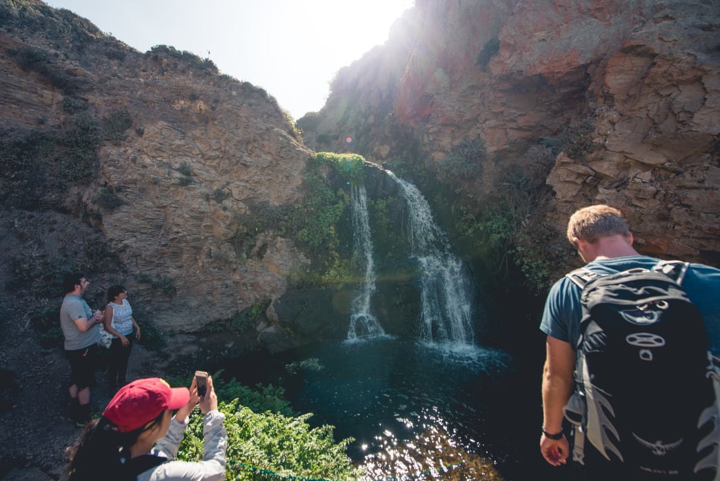
Alamere Falls is a dramatic 40-foot tidefall, a coastal waterfall which pours its waters into the waves of the Pacific Ocean. The larger of only two tidefalls in the entire state of California, it is an unusual and enticing site for even the most seasoned explorers.The beautiful 7.5 mile out and back hike to get to it offers countless spring wildflowers, wide ocean views, gray whale watching opportunities, and access to both Bass and Pelican Lakes making it great for experienced hikers.
What Makes It Great
From the Palomarin Head parking lot take the wooden stairs that lead to the Coast Trail. Head left and pass through a large eucalyptus grove fills the air with its refreshing scent. Turn left off the trail here to head down to Palomarin Beach to enjoy the sun and surf, otherwise continue straight to get to the falls.
A huge expanse of ocean will unfold to the west as you move across the rugged bluffs. Off in the distance, you will see the muted contours of the Farallones Islands and further south, Montara Mountain will come into view. During the spring, you’ll encounter spectacular fields of vibrant wildflowers—all colors, shapes and sizes.
After a mile or so, the trail will head inland through patches of woods, then climb gradually until it resolves around Pelican Lakes. Here, feel free to take a detour to walk the perimeter and catch glimpses of the pond’s salamanders and frogs. Or, head to Bass Lake—one of the few lakes in the area that allows swimming. Be sure to bring a swimsuit if you’d like to take dip.
Once you’ve made it past the lakes on the Coast Trail, the route will descend and the ocean will become visible in the distance. However, don’t allow the ocean viewing make you miss the signpost on the left for Alamere Falls. Yes, this narrow, singletrack and seemingly overgrown trail is the one you need to follow to get to your destination. You may want to consider protecting your arms and legs at this point.
After about 0.5 mile, the brush falls away and you’ll find yourself standing upon a grassy bluff overlooking the upper portion of Alamere Falls. Head carefully down the short rock gully and cross the stream (which can be a little tricky after rains). Feel free to stop on this lower section of bluffs and look for periodic whale spouts on the vast glittering ocean, or call it a day and enjoy a picnic.
If you’re intent on viewing the falls from the beach, a steeper and more unstable scramble awaits. Follow the well-worn path north and away from where Alamere Falls drops over the cliff. Use extra caution since the gully is unstable. Once you’re on the beach you can frolic and make merry in the cascade’s waters. Retrace your steps for a 7.5-mile out and back.
If you can’t get enough of this trail, head north on the scenic coastline for another mile toward Wildcat Beach. Oftentimes, equestrians allow their horses to gallop along this strip—it’s a breathtaking sight. Wildcat Beach offers great camping spots hidden away behind patches of tall, yellow spring flowers. Take the Coast Trail from Wildcat to return to Palomarin trailhead (about an 11 mile loop). Several longer loop options are possible as well.
Who is Going to Love It
This trail/loop offers opportunities for day-hikers, overnight backpackers, trail runners, equestrians, enthusiastic lake swimmers, and naturalists. Trails nearby offer strenuous rides for mountain bikers as well.
Directions, Parking, & Regulations
Take US-101 into Marin County, then exit onto CA 1/Mill Valley/Stinson Beach. Continue via Shoreline Highway/ CA 1 for 1 mile to its intersection with Almonte. Turn left and drive about 2.5 miles to the junction with Panoramic Hwy. Continue straight on CA 1 past Muir Beach, Stinson Beach and along the eastern shoreline of Bolinas Lagoon-about 13 miles-to an unsigned junction with Olema-Bolinas Road. Turn left and follow the western edge of Bolinas Lagoon. Go 0.1 mile to a T intersection with Olema-Bolinas Road and take a left, then drive about 1 mile to the junction with Horseshoe Hill Road and turn left. Turn right on Mesa Road. Drive about 4 miles to the trailhead at the end of the road. The last mile is gravel.
Parking is plentiful and there are two wheelchair accessible toilets, but there is no drinking water.
Written by Marta Haftek for RootsRated and legally licensed through the Matcha publisher network. Please direct all licensing questions to legal@getmatcha.com.


